
Save time by getting all your answers...
Get all your answers by typing just one address...


Population density heatmap, lightning strikes, suburb risk factors (crime, natural disaster, accessibility)
A small subset of these answers includes:
- Display the information on interactive, high speed heatmaps with location insights on your phone, tablet or laptop.
- Overlay the address on a map with recent satellite imagery or from a decade ago.
- Weather Information, rainfall, forecast etc.
- Extreme weather conditions - predictive and historic
- Storm tracking
- Severe weather alerts
- Lightning reports with strike intensity, amount of strikes, areas and times in near real-time or historic
- Kick off a location-based conversation
- Suburb risk reports
- Show the erf boundary
- What are the population demographics like?
- Which business are registered here?
- What is the postal code?
- Which other suburbs share this postal code?
- Crime statistics
- Dolomite or clay soil?
- Far from a police or fire station?
- Progress from knowing the address to doing a person search at your credit bureau of choice.
- And more...
Answers provided by smiling faces, software interfaces or developer API's.
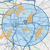
Hatfield areaConfidence ellipses of lightning strikes
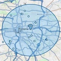
Hatfield areaLocation points of lightning strikes
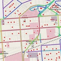
Hatfield areaCIPC data, gated communities, traffic
"Risk comes from not knowing what you're doing." Warren Buffett
If you want to know more email AfriGIS.co.za]]
We create ONE OF A KIND GEOSPATIAL SOLUTIONS. We use geospatial information science to bring information about WHERE to life across industries and in any application. This helps our clients unlock value through better business intelligence.
- Turning strategy into action: How AfriGIS supports SA’s geospatial information management strategy?27 Oct 09:56
- Geospatial in Africa: The highs, the lows, and what’s ahead in 202508 Oct 12:13
- AfriGIS preserving South Africa’s heritage02 Oct 16:08
- Restoring trust in municipalities through GIS-enabled asset management systems29 Sep 13:56
- How geospatial insights can transform service delivery planning and analysis in South Africa03 Sep 10:09


